
|
Where are we?
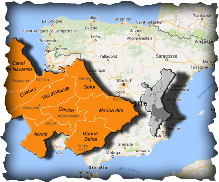
Our Region We are in Spain, and how it say the song, land of sun and pleasures. Our region belongs to the Comunidad Valenciana and is situated between provinces of Valencia and Alicante. Our area is one of the most mountainous of Spain, even though they are not very high its heights, do not leave anyone indifferent its steep and rugged mountains with big slopes where we'll find pocentages upper than 22%. |
|
|
Arrival Day
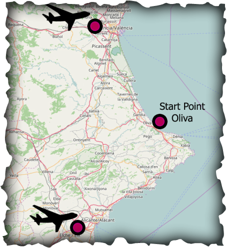
Flights to Valencia or Alicante and self transfer to Oliva Nova Golf Hotel, in Oliva. This Night's accommodation is included in your itinerary. ACCOMMODATION Oliva Nova Golf Hotel Start Town Oliva is a municipality in the Comarca of Safor in the Valencian Community. To its east lie 10 kilometres of coastline and beaches fronting the Mediterranean Sea. Oliva's Old Town has historical streets which see various fiestas celebrated throughout the year. In the old town there are two churches, Sant Roc and Santa Maria la Major. Sant Roc dates from the 18th-19th centuries, and Santa Maria from the 17th-18th centuries. At the top of the hill in the old town is Santa Anna Castle which was built in the 16th century. |
|
|
Day 1
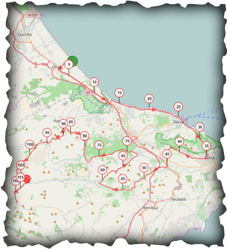
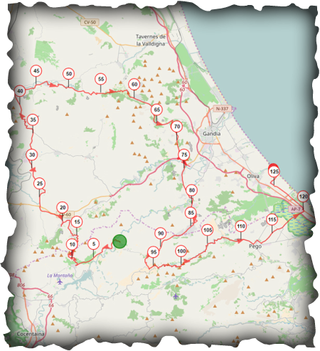
Oliva - Castell de Castells Oliva to Castells, roughly 120KM with around 2000 meters of climbing. The first stage, will see us leave Oliva along the coastal route to Denia, where we’ll encounter the first mountain pass, "El Montgo", although there is often traffic on this ascent as the road unites the two coastal towns of Denia and Xavea the views and experience are well worth it. Next on this tour we’ll navigate the impressive massif and enter into wine producing lands on our way to Xaló. From here, we will go to Pedreguer and later to Orba on rolling foothills until the mountain pass of Sagra and the slightly larger pass of Vall d'Ebo. This pass was used in the 21st stage of the 2016 edition of the Vuelta a España and actually produced the day’s escape. Once in Ebo we will continue to Pla de Petracos, where we will find the most important cave paintings in the Mediterranean, dating back 5000 years. The route will take us to through the areas and towns where the infamous battles between the Moors and the Christians took place between the twelfth and seventeenth centuries. From here we’ll head to Castell de Castells, the village which will welcome us at the end of this first stage, and where the good home cooking will help us regain our strength for the days to come.
|
|
|
Day 2
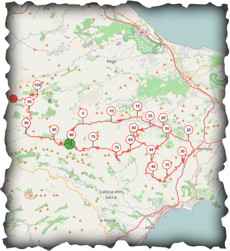
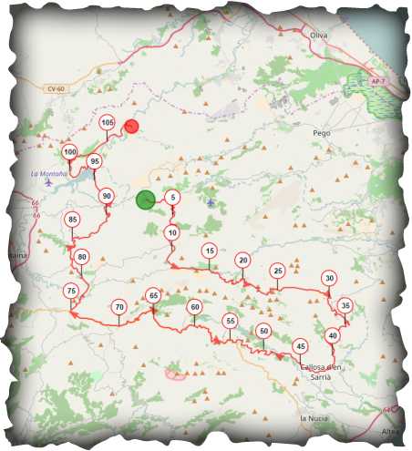
Castell de Castells - Margarida Castell de Castells to Margarida roughly 105km with around 2000 meters of climbing. The second stage will require us to breakfast well as although the day is shorter than yesterday the climbing starts almost immediately. The route contains some stunning mountain passes, where we will touch slopes of up to 22%, not for very long, but long enough to force us to grit our teeth. From the mountain pass of the Sierra Bernia we will have earned views over the Mediterranean Sea, and the Ifach Rock, an imposing block of rock 332 meters high which guards the Mediterranean. From Bernia we can see part of the route of the third day, before starting the descent towards Xaló. After Xaló we’ll head to the Coll de Rates, another mythical stop in the Vuelta a España. But this time we will only make the climb to Tarbena where we will divert to the right in search of Valle del Pop through a succession of rolling hills which will take us once again through Castell de Castell. The last mountain pass of the day, which is immersed in a pine forest, will climb up to the Tollos Wall. A short steep ascent of 22% which allows us to leave the Ceta Valley and gain access into the Alcalá Valley and then on to Margarida and the end of the second stage. We will be hosted in the rural house of l'Almàssera, a quaint inn with exceptional cuisine which our palate will surely enjoy.
|
|
|
Day 3
Margarida - L'Orxa Margarida to l'Orxa roughly 110km with around 2000 meters of climbing . The Queen stage of the Tour de les Valls, where we will retrace the last 30km of yesterday’s route, but without confronting the hard walls of Tollos and Castell de Castells. Once at Tarbena we’ll descend the legendary Coll de Rates towards Callosa d'En Sarria. The city is famous for its loquat fruits which have unrivalled flavour and size. From here we will begin the biggest ascent of the entire route, a 27km climb with an average grade of 3%, linking the towns of Guadalest and Confrides. We will pass through Guadalest, a picturesque tourist town crowned by the San José castle (XIth century), which is one of the jewels of the Marina Baixa. We will continue on to Confrides and then the top of the mountain pass. At the summit we’ll descend through valleys into the new region of Comptat via a succession of small towns, with charming roads between pine trees and gorges, with stretches of desert like terrain far to the west. Little by little we’ll reach Planes de la Baronía with its imposing twelfth century castle, who the Vizier Al-Azraq had command and control over. We will leave the village on route to the Beniarres reservoir and from here, we’ll cross the Perputxent Valley and the meandering Serpis river, to arrive in the village of l'Orxa. This is the end of this hard third stage. Here we will stay in the Trinquetera rural house, where we will be able to taste a wide variety of local food in the bars of the village.
|
|
|
Day 4
L'Orxa - Oliva L'Orxa to Oliva roughly 130km with around 2000 meters of climbing. We leave l'Orxa heading towards Beniarres with our eyes fixed on the first of the day’s sunrays over the Perputxent Valley. This valley is guarded by the castle of the same name, which after expelling the Arabs from Spain, passed to the Templar Knights. It is also the last castle which had the Order in this region before its disappearance and conversion to the Order of Montesa. Here we arrive at the first climb of the day, the Beniarres mountain pass, which is 6.5km long with an average of 4%. When we reach the top, we’ll leave the province of Alicante to enter that of Valencia and go from the Perputxent Valley to the Vall d'Albaida. A vast plain of terraces full of almond and olive trees welcomes us. To our left we have the Benicadell peak, which at 1,104 meters is the natural border between provinces and whose summit we ascend on the Tour de les Valls Trail Running trip. We will descend towards Castelló de Rugat by a mountain pass full of curves and with the valley on our left. Once in the town we will take the main road to the village of El Genovés. From here we’ll start the ascent of the Pla de Corrals, a gem among pines which will take us to Marxuquera on the cycle lane that avoids us taking the highway. Once the cycle lane ends, we’ll continue through the towns of Palma and Ador, until we will reach Villalonga, a town famous for its water sources and the mountain which gives its name to the region, La Safor. From Villalonga we begin the final ascent of the Tour de les Valls, the Llacuna mountain pass which ends with a tough steep slope of 13%. From the summit we’ll head back to the province of Alicante to immerse ourselves in the Vall de Gallinera, the valley of cherry, almond and carob trees, which in the spring are an explosion of colours and smells which has to be experienced to fully appreciate. The valley ends in a beautiful canyon that will take us to Pego and from here to the natural park of the Marjal. It is a unique park in the province due to its characteristics of housing one of the mightiest rivers of Europe which its source is just 6.5km from the sea. The river also provides this park with one of the most important aquifers of the peninsula. Once past the park, we go in search of the old road of Denia to reach Oliva, the end of the last stage and of the TnT de les valls.
|
|